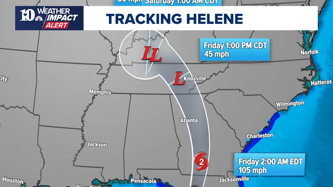
KNOXVILLE, Tenn. — Update 9/30 (7:15 a.m.)
A Flood Warning has been issued for the Tennessee counties of Cocke & Jefferson until 4:15 PM on Monday, Sept. 30.
An Areal Flood Warning for the Tennessee counties of Knox & Sevier is in effect until 7:30 PM on Tuesday, Oct. 1.
Update (11:20 a.m.)
The National Weather Service has issued a flood warning in Knox and Sevier counties until 8:00 p.m. EDT along the French Broad River from Douglas Dam to a merge with the Tennessee River. Flooding is caused by an upstream dam release.
A Flash Flood Warning has been issued for Knox County until 8 p.m. EDT. A Flash Flood warning has been issued for Cocke, Greene and Hamblen counties until 4:00 p.m on Saturday.
A Flash Flood Warning has been extended for Jefferson County until 12:36 p.m. on Sunday. Sept. 29.
Update (9:00 a.m.):
The National Weather Service has canceled the Flash Flood warning extension in Sevier County.
Update 9/28 (7:13 a.m.):
The National Weather Service has extended a Flash Flood Warning for Jefferson County and Sevier County, lasting until 10:00 a.m. EDT on Saturday.
A Flash Flood Warning has also been extended for Greene County, Cocke County and Hamblen County until noon EDT on Saturday.
------
//**A Flash Flood Watch was issued for Greene County, Cocke County and Hamblen County until 6 a.m. on Sept. 28**//
Storms swept through East Tennessee Friday, dumping rain and sparking flooding concerns for most of the day.
A Flash Flood Warning is in effect for Erwin, Banner Hill, Mountain City, Shouns and Roan Mountain areas of Tennessee until 8 p.m. EDT.
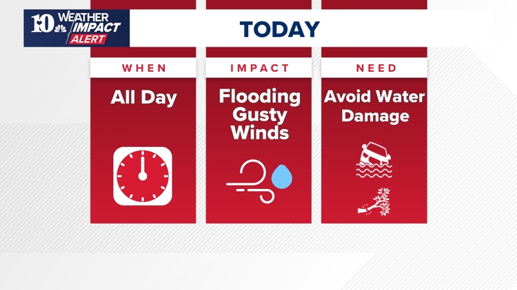
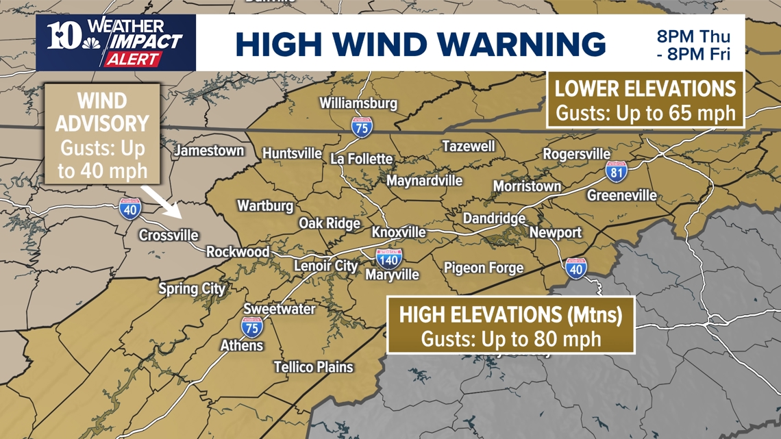
A Flood Watch was in effect for the region, along with a High Wind Warning for nearly all of East Tennessee. The wind warning is expected to expire at around 8 p.m. on Friday, and the Flood Watch has since expired for many areas.
Winds could reach around 80 mph in the higher elevations, such as areas like Pigeon Forge and Townsend. Lower elevations could still see gusts of around 65 mph though, still capable of damaging homes and sending debris flying.
They could also topple trees across East Tennessee, taking down power lines and possibly knocking out power for several communities. So, people should make sure to prepare in case the electricity goes out such as by charging devices, having battery packs and stocking nonperishable food.

During storms, people should remember never to drive through puddles. There's no way to tell how deep they are, and driving through a flooded area can damage cars and trap people inside. Whenever anyone hears thunder, they should also head indoors to avoid dangerous winds and rain.
When will the weather impact me the most?

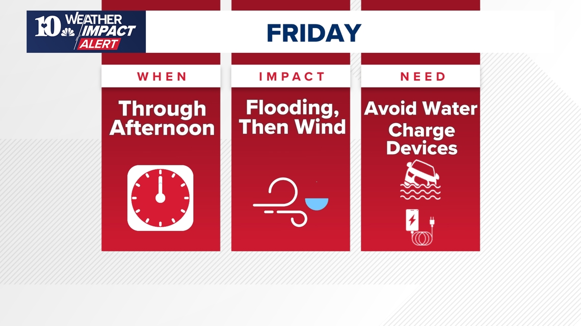
On Friday, people could expect to wake up to rain showers lasting through the morning. They should start to taper off as the winds pick up in the morning. People may experience a brief "lull" in the winds as the storm passes over and pulls way to the west later in the afternoon and evening.
Before then though, trees will be at risk of toppling over. The wind should also switch directions, effectively tugging at trees and weakening their roots in soil that was already weak from drought conditions and is now wet.

How can the weather impact me?
Heavy rain can cause flooding, block roads and potentially damage homes. People should take precautions in case of flooding, such as staying vigilant in areas prone to floods. Most of the time, these can be near creeks and rivers. Anyone on the road when storms roll in should also make sure not to drive through large puddles.
Often, puddles can be deeper than they appear and trying to drive through them can damage cars and trap people inside them. Avoid puddles while on the road. If there's thunder, people should also take shelter inside a sturdy building.
Strong winds can also send debris flying, possibly causing further damage to buildings.
East Tennessee has also gone through a recent drought, resulting in dry soil that both elevates flooding risks and weakens roots. During strong winds, there is also a chance for trees to topple, blocking roads and damaging homes. They could also hit power lines, knocking out electricity for people in the area.
Before Hurricane Helene moves into East Tennessee, people should make sure they have everything they may need in case the power goes out or their home is damaged. That includes any necessary medication, a flashlight, a way to stay updated on the weather and charged battery packs for their phones.