KNOXVILLE, Tenn. — The days are getting shorter and the temperatures are getting cooler, so it's time to get ready for the cold months ahead.
We see all kinds of weather during the winter season in East Tennessee, from severe weather, to rain, to sleet, to snow...and sometimes we do all of that in the same day! Sometimes, winter decides to give us an unexpected preview -- like the snow we saw in mid-October in the upper elevations.
As you can imagine, forecasting exactly who is going to see what and when can be kind of tricky, which is why we want to get you prepared now so you'll be ready for anything as we go through the winter season.
Let’s start by talking about the main factors that will come into play when we are projecting snow totals for the next couple of months.
Meet The "Horseshoe"
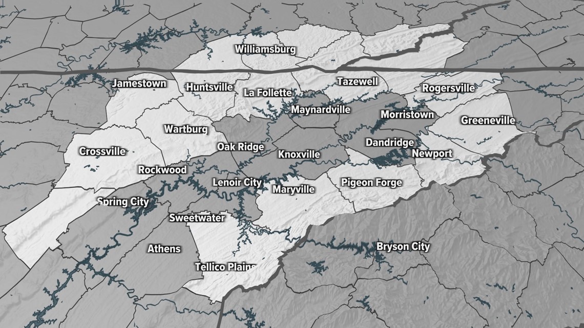
If you’ve lived in Tennessee for quite some time you’re probably aware of the different elevations of East Tennessee that make up the "horseshoe": the Cumberland Plateau and Cumberland Mountains to the west and north of Knoxville, the Great Smoky Mountains and Foothills to the south and east, and the Valley in the center.
So why is it called the horseshoe? The higher-elevation counties that surround the Valley form a shape that looks like a horseshoe, as seen below.


If you’re new to town, you should know this "horseshoe effect" plays a big role with the kind of weather we see during the winter season. It's often the source of disappointment, surprise, or relief for people in Knoxville when a winter storm passes through East Tennessee.
Snowfall totals tend to be higher as you go up in elevation. For example, Crossville is located on the Cumberland Plateau and has an elevation of about 1,850 feet. The city averages about 11.5 inches of snow each winter.
Meanwhile, Knoxville is located in the Valley with an elevation of about 880 feet and only averages about 6 inches of snow each winter.
If you really want to see some big snow totals, just travel up to the highest elevations of the Smokies (if the roads are open). Clingmans Dome averages anywhere from 6 to 8 feet of snow over the winter months.
How Much Snow Will We See?
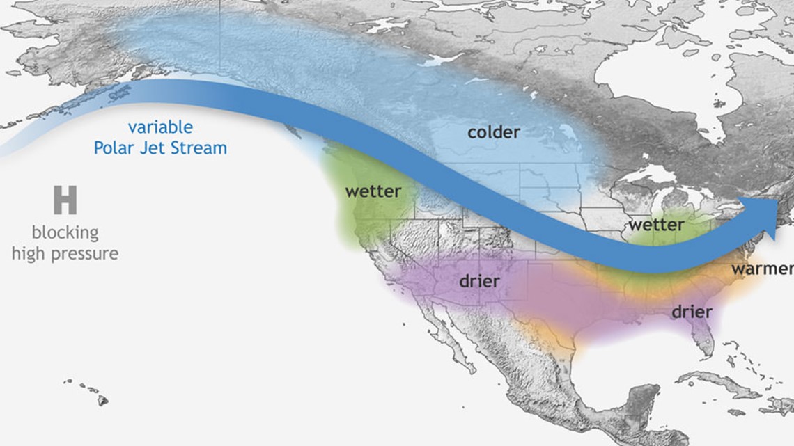
We will once again be in a La Niña pattern this winter similar to last year. La Niña typically produces slightly warmer-than-average temperatures and near-average precipitation for our area during the winter season.
While the Knoxville area ended up with above-average snowfall last year, not everyone saw equal amounts. It all comes down to each individual storm and the specific track they take. Clippers will typically bring light accumulations, while low-pressure systems that form near the Gulf and track northeast bring heavier snowfall.
When it comes to forecasting winter weather, models will typically show a chance for wintry weather a week or more out. But that’s way too early to get specific with the details. That will come later when we’re about one to two days out and we start to fine-tune the snowfall amounts.
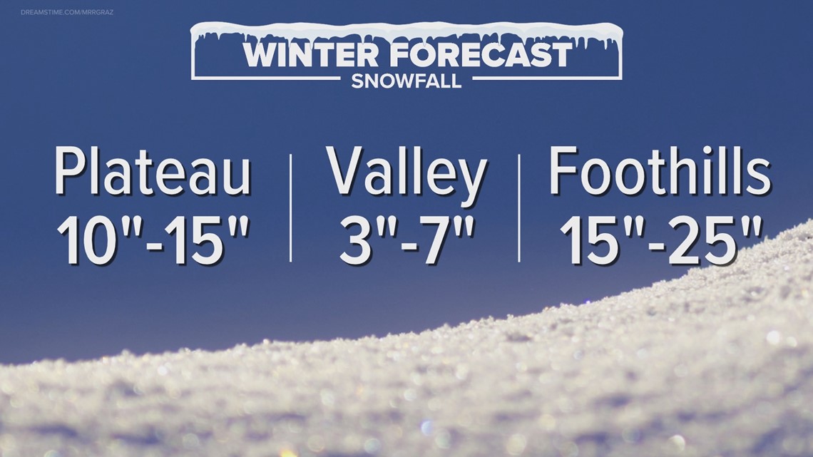
So what about snowfall for our region this winter season? Overall, near-average snowfall is expected for East Tennessee.
For the Cumberland Plateau and Cumberland Mountains region, a range of 10 to 15 inches of snow is expected. For the Valley region, we're expecting a range of 3 to 7 inches, which is really close to the average snow for Knoxville of 4.6 inches. And for the Foothills region along the Smokies, a range of 15 to 25 inches of snow is expected.


As for temperatures this winter, we are expected to be slightly warmer than average. However, you can still get arctic outbreak intrusions in a La Niña pattern!
In summary, snowfall around our region is highly dependent on topography and elevation. Higher elevations like the Cumberland Plateau and Smoky Mountains will typically see more snow than lower-elevation valley areas like Knoxville. The higher up you go, the more it will snow! And amounts can vary widely from place to place. So always be sure to pay attention to the latest weather conditions this winter and stay ready when snow is in the forecast!
What is La Niña
Trade winds typically blow from east to west across the Eastern Equatorial Pacific Ocean.
When those trade winds are stronger than normal, they take warm water at the surface away from the coast of South America, allowing cool water to "upwell."
This "cooling" of the water in the Pacific Ocean can affect the large-scale weather pattern, pushing the jet stream farther north than normal.
For the United States, this usually means colder-than-average conditions for the Northern Plains and warmer-than-average temperatures for the southern tier of the Lower 48.


The same areas that are typically warmer are also usually drier during a La Nina pattern.
Wetter-than-average weather is expected in the Pacific Northwest and in the Ohio and Mississippi River Valleys.
So for East Tennessee, we kind of get stuck in the middle.
It should also be noted that two other climate patterns, the Arctic Oscillation and the North Atlantic Oscillation, also play a big role in allowing cold air to come to the Southeast.
Download our free WBIR weather app (Apple, Google Play) with interactive radar and follow us on social media!
WBIR Weather on Facebook
WBIR Weather on Twitter
Todd Howell on Twitter
Mike Witcher on Twitter
Rebecca Sweet on Twitter
Kaylee Bowers on Twitter
Tevian Whitehurst on Twitter
Make it easy to keep up-to-date: Download the WBIR 10News app now and sign up for our Take 10 Lunchtime Newsletter.
Have a news tip? Email 10Listens@wbir.com, or visit our Facebook page or Twitter feed.

