Watch 10News' live snow coverage starting at 10 p.m. on WTNZ Fox 43, and continuing through at 11 p.m. on WBIR Channel 10.
Latest weather update: http://www.wbir.com/weather
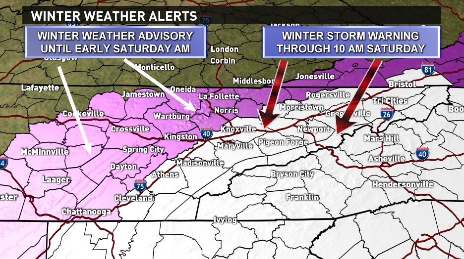
Winter Storm Warning will be in effect from 7 p.m. tonight through 10 a.m. Saturday for the eastern Valley and Smoky Mountains.
A Winter Weather Advisory will be in effect for the western Valley and Plateau through Saturday morning.
A Wind Chill Advisory will be in effect for the foothills, Smoky Mountains and parts of the Plateau from 1 a.m. to 1 p.m. Saturday with wind chills down to -5 to -10 degrees.
Tonight: More snow is expected tonight, especially for the eastern half of the Valley and Smoky Mountains. Totals could be 1-4 inches in the Central Valley, 3-4 inches in the Northern Valley and 6-8 inches in the foothills and Mountains. There will be a sharp gradient between areas that see the heavier snow and areas that see only light accumulations. Much lighter totals are expected in the western Valley and on the Plateau. It’s also going to be COLD tonight! Lows will fall into the teens across the area with wind chills in the single digits in the Valley. Wind chills could be as low as -5 to -10 degrees in the higher elevations. Winds will be out of the north at 5-10 mph.
Saturday: Snow will come to an end early with a few lingering snow showers possible in the mountains. Temperatures will remain cold with highs only reaching the lower to middle 20s despite the clearing skies. Northerly winds at 5-10 mph will keep wind chills in the single digits and teens all day so layer up and accessorize if you need to be outside! Overnight lows Saturday night into Sunday morning will be in the single digits across the entire area… the coldest night we’ve seen in almost 2 years!
Sunday/Next week: Highs will be around 30 degrees Sunday afternoon and back down into the single digits and teens Sunday night into Monday morning. A quick warming trend will bring highs back into the lower 50s by midweek. Our next chance of rain arrives late Tuesday night into Wednesday.
Have a great weekend... stay warm!!
You can get up-to-the-minute weather updates on our Facebook Page (WBIR Weather), by following us on Twitter (@WBIRWeather) or by signing up for the WBIR news and/or weather app.
Facebook pages for WBIR Meteorologists/Weathercasters: Todd Howell, Matt Sanderson, Cassie Nall and Rebecca Sweet.
Twitter pages for WBIR Meteorologists/Weathercasters: Todd Howell, Matt Sanderson, Cassie Nall and Rebecca Sweet.