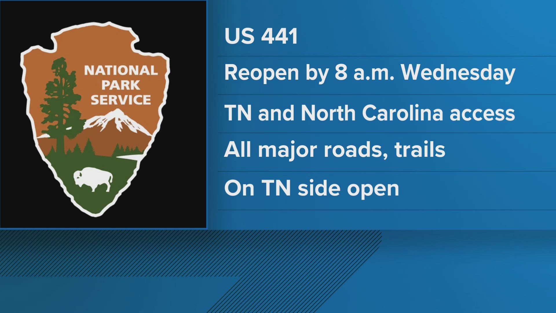
Great Smoky Mountains Natl. Park — UPDATE 3 PM OCT. 1: The National Park Service anticipates re-opening Newfound Gap Road, also known as US Highway 441, by 8 a.m. Wednesday, the Park Service announced Tuesday.
The road is a major link between Tennessee and North Carolina through Great Smoky Mountains National Park. It's been closed since the remnants of Hurricane Helene swept into the Southeast late last week.
"Once US 441 reopens, all major roads, trails and facilities on the Tennessee side of the park will be open to visitors. Kuwohi Road (formerly Clingmans Dome Road) will also open tomorrow. While the park has assessed high-use areas and trails for hazard and downed trees, visitors should exercise extra caution as they hike and explore the park," the Park Service said Tuesday.
Commercial vehicles are not allowed on US 441.
Thanks in part to the city of Gatlinburg, and with support from the NPS Eastern Incident Management Team, "the park received a needed fuel delivery to the Oconaluftee area today which is helping the park to reopen the road (Wednesday)."
Park officials continue to suggest that while the region deals with the storm disaster that visitors consider a different time to plans a Smokies visit.
Avoid water recreation if you're coming to the park. Also remember that emergency services already are strained and it could take longer than usual if you need urgent help from authorities. Some parts of the park are still closed including Cataloochee Valley, Big Creek, Balsam Mountain and Lakeview Drive are still closed.
Also, the Oconaluftee and Kuwohi visitor centers are closed. Check current park conditions before heading to an area of the park.
UPDATE (Sept. 30, 3:30 p.m.): The National Park Service said it is continuing to assess road conditions after Hurricane Helene sparked widespread flooding across upper East Tennessee and in the Great Smoky Mountains National Park.
It said several roads, including Newfound Gap Road, were still closed as of Monday afternoon. It also said there were no estimates for when they would reopen. The NPS encouraged people to visit its website for updates on when roads would be open, and which roads were open.
The NPS also said staff and resources were focused on helping the Great Smoky Mountains. It said many park employees in North Carolina and Tennessee were facing emergencies at home or were unable to get to work due to closed roads. Some other workers were also helping in the Blue Ridge Parkway area and in surrounding communities.
It encouraged visitors to reschedule their trips to the Great Smoky Mountains and said it is not recommended people take hiking or backcountry trips after historic flooding.
A list of the roads and areas closed in the Great Smoky Mountains as of Monday afternoon is below.
- Balsam Mountain area, campground and roads.
- Big Creek area, campground and roads.
- Cataloochee Valley area, campground and roads (including Hwy 284).
- Deep Creek (the creek itself) between Indian Creek Bridge and the park boundary closed to all water activity.
- Deep Creek Campground.
- Foothills Parkway East.
- Kuwohi Road (formerly known as Clingmans Dome Road).
- Kuwohi Visitor Center.
- Lakeview Drive.
- Newfound Gap Road/Hwy 441.
- Oconaluftee Visitor Center.
- Parson Branch Road (due to Flint Gap Fire impacts).
- Smokemont Campground.
The Great Smoky Mountains National Park also released a statement for anyone considering a visit to the park.
"Wondering whether you should reschedule your trip to the Smokies due to impacts from Hurricane Helene? While parts of the national park are open, outdoor recreation is currently discouraged due to park staffing being stretched and visitor safety concerns. However, Sevier County, which includes Gatlinburg, Pigeon Forge, and Sevierville, is fully open to those who can access the county through safe routes. We are working hard to get all major park roads open to the public as soon as possible."
--
Great Smoky Mountains National Park authorities have reopened some roads and centers that had closed because of the tropical storm. Some popular facilities and roads, however, remain closed, and authorities are urging caution to visitors thinking of visiting the park.
Further, neither hiking nor backcountry travel is advised because the park still is dealing with so much water and potential damage. Creek crossings can be treacherous and hikers may run into downed trees and bad trail conditions in the 520,000-acre park that spans parts of East Tennessee and Western North Carolina.
If possible, the park said Saturday, visitors should plan to come to the Smokies at a later time.
Among the areas that reopened Saturday were Sugarlands Visitor Center and Cades Cove Visitor Center and Cable Mill.
Also, these roads reopened Saturday: Cades Cove Loop Road (including Sparks & Hyatt lanes); Little River Road; Wear Cove Gap Road; Cherokee Orchard Road; and Lakeview Drive.
Many key roads and trails are still closed.
They include:
*Newfound Gap Road/Hwy 441 (reopening time to be determined)
*Foothills Parkway East
*Roaring Fork Motor Nature Trail
*Balsam Mountain area, campground and roads
*Cataloochee Valley area, campground and roads (including Hwy 284)
*Big Creek area, campground and roads
*Greenbrier area and roads
*Oconaluftee Visitor Center (through at least Sunday)
*Kuwohi Visitor Center (through at least Sunday)
*Kuwohi Road (formerly known as Clingmans Dome Road)
*Rich Mountain Road
*The Deep Creek between Indian Creek Bridge and park boundary (closed to all water activity)
*Parson Branch Road due to Flint Gap Fire impacts