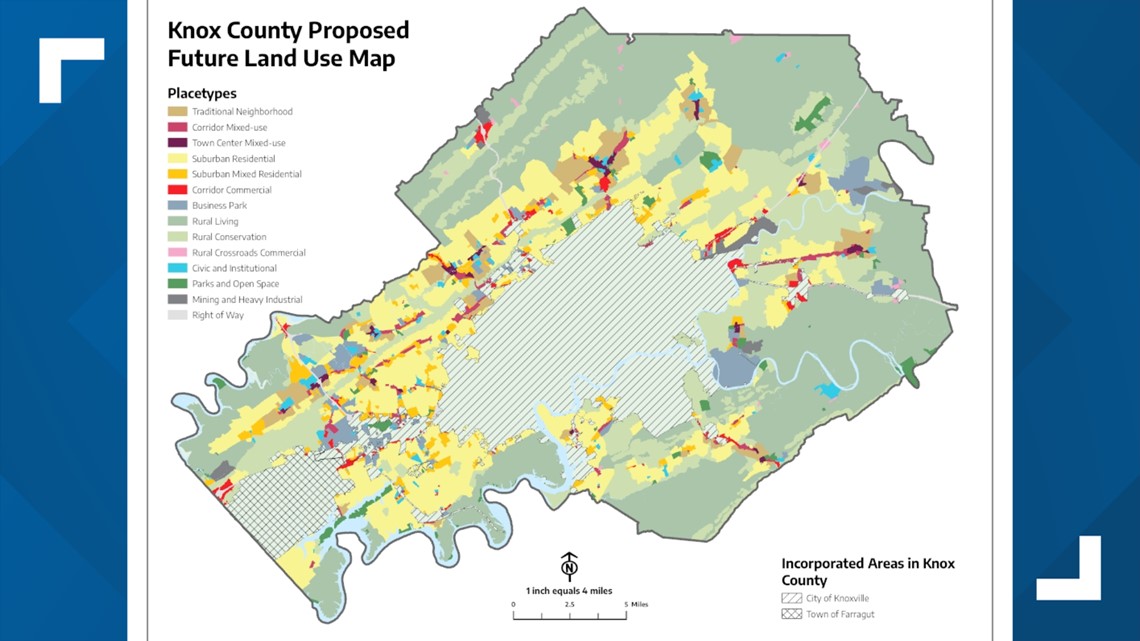
KNOX COUNTY, Tenn. — In October, Advance Knox released its draft plan meant to guide decisions on how Knox County could grow over the coming decades. The program also unveiled a proposed future land use map, detailing the way stakeholders believed different areas of the county should be developed.
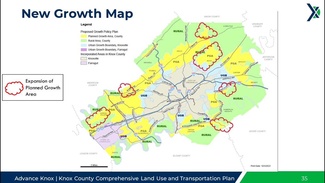
After releasing its draft plan, Advance Knox held a meeting for the Growth Policy Coordinating Committee. The committee is tasked with formally updating the county's Growth Policy Plan and its accompanying map. It's made up of 12 members, all representing different organizations and components of county leadership.
There, they presented the initial proposed map and detailed the next steps in the process of guiding the future of Knox County's growth and development.


During the presentation, they said leaders need to designate an urban growth boundary, a planned growth boundary, and a rural growth boundary. During the presentation, they also recommended that rezonings in rural areas be limited to rural crossroads, rural conservation and rural living types of areas.
Some of the people who attended Tuesday's meeting said they wanted to see more effort to preserve rural areas.
"As a farmer, it's our livelihood. It is a business," said Adam Thompson, a sixth-generation farmer who raises cattle and produces hay. "If this is implemented, all that's going to change. We have thousands of acres that have been added to that planned growth area that are covering prime farmland."
Committee members said Advance Knox made an effort to preserve rural areas while also finding room for the county to grow and for more buildings to be built. As part of their recommendations, they said residential development in rural areas should be limited to areas where no more than two dwelling units per acre, with sewer and water utilities available.
"We wanted to be very intentional about preserving that rural space, and in this amendment," said Jim Snowden, Senior Director of Engineering and Public Works at Knox County. "This plan gives us the ability to grow in ways that we currently don't right now. Our zoning ordinance is very old and antiquated. It's 30 years old."
The new growth map proposed at the meeting included allowing for development in rural areas around Gibbs, in Hardin Valley, down Chapman Highway and along West Emory Road. It adds around 11,250 acres of planned growth area, and leaders said the new areas align with "existing or proposed infrastructure and market trends."


"The prime farmland is also the easiest to develop because it's flat," said Thompson. "Once farmland is gone, you never get it back."
The current map recommends most of the county's future development be "suburban residential," describing areas for single-family homes with lot sizes less than one acre.
This type of growth features future developments with street and path connections to adjacent neighborhoods, all within a walkable distance to parks. It also says they should be a bikeable distance to commercial areas.
It also recommends most of the western outskirts of Knoxville include "rural crossroads commercial" areas. These areas are predominately at intersections within rural areas, offering goods and services that meet day-to-day and agricultural needs.
It recommends the northern and eastern outskirts of Knoxville feature "corridor commercial" areas. These areas have a mix of commercial developments like shopping centers, large-format retail and "auto-oriented uses." Developments are mostly made of one-story, large-footprint buildings but can also include multi-story hotels.
The next meeting of the committee will be on Nov. 16, before the Knox County Commission, Knoxville City Council and other leaders can take legislative action.

