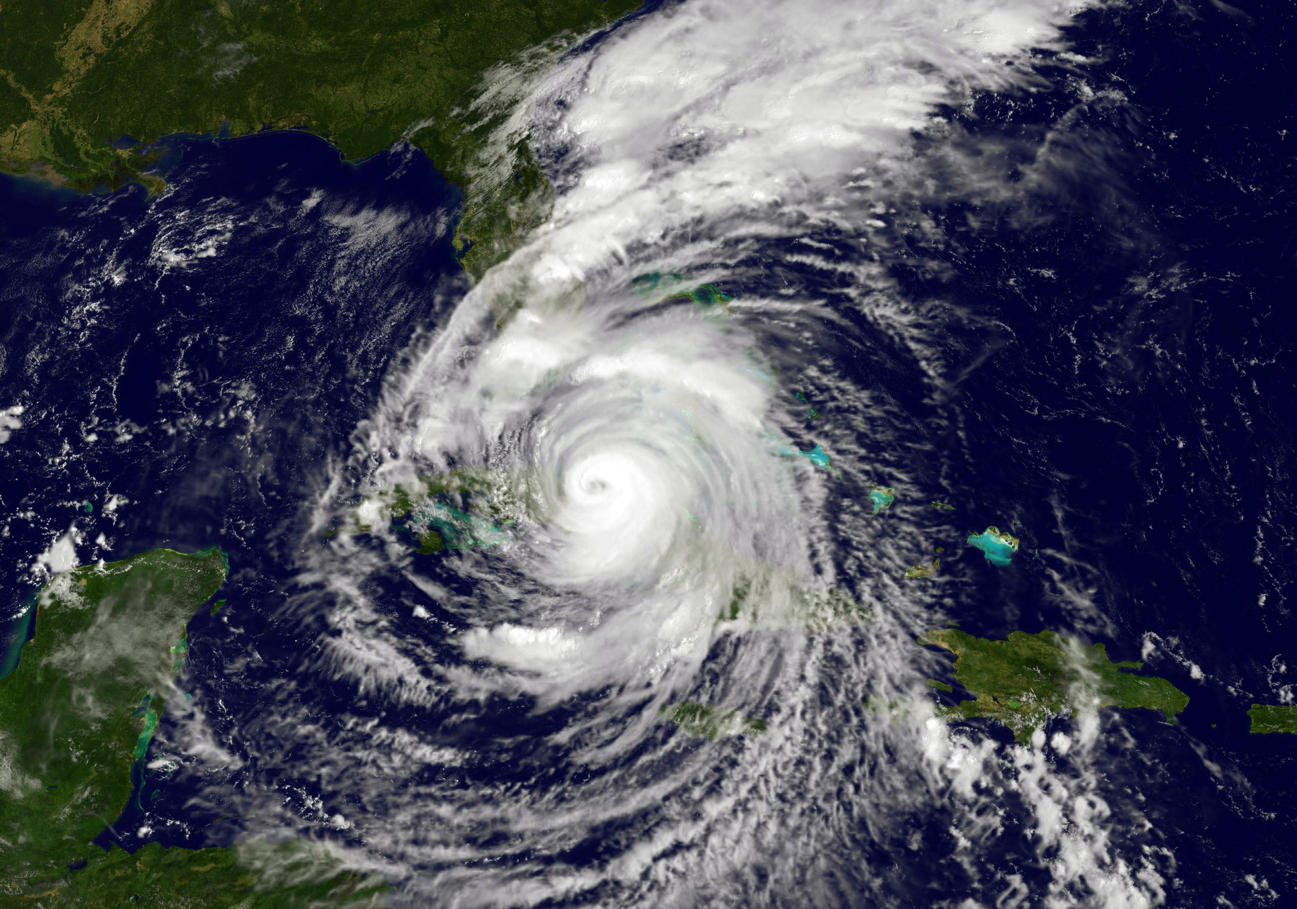
Hurricane Irma returned to a Category 4 storm early Sunday and started to move faster along the ocean as the northern eyewall reached the Forida Keys early Sunday.
Packing sustained winds of up to 130 mph, the National Hurricane Center said the storm was about 40 miles off the Keys at 5 a.m. ET and moving northwest at about 8 mph, meaning that its eye would make landfall in the mid-morning.
As the storm approached, wind speeds in coastal areas increased, with trees in Miami and other areas of South Florida swaying violently as rain lashed streets and buildings.
Early Sunday, the National Weather Service tweeted "the worst winds are yet to come."
***EVERYONE IN THE FLORIDA KEYS***
***IT IS TIME TO HUNKER DOWN***
***THE WORST WINDS ARE YET TO COME***#Irma #FLkeys #flwx pic.twitter.com/lmHTcRv68l
— NWS Key West (@NWSKeyWest) September 10, 2017Meanwhile, only hours before Irma was expected to slam into the state, a last-minute shift in its projected track put the Tampa Bay area in line for a direct hit and triggered new mandatory evacuation orders for another quarter-million people.
The new track, farther west than earlier projections, would make the Tampa-St.Petersburg area the bullseye for a major hurricane for the first time in almost a century.
The latest forecast calls for Irma, which has cleared the Cuban coast and headed into the Florida Straits, to roar ashore Sunday in the low-lying Florida Keys, then hit southwestern Florida, move up the state’s Gulf Coast and slam into the Tampa Bay area. Forecasters warned of 10- to 15-foot storm surges in the Naples area and 5 to 8 feet around Tampa-St. Petersburg.
The Tampa Bay area has not been hit by a major hurricane since 1921, when its population was about 50,000, said National Hurricane Center spokesman Dennis Feltgen. Today the area has around 3 million people and includes two of Florida’s biggest cities: Tampa and St. Petersburg.
Armed with the new forecast, Pinellas County, home to St. Petersburg, ordered 260,000 more people to leave. A hurricane warning for both coasts of the Florida peninsula up through central parts of the state was in effect.
In the Florida panhandle, Franklin County officials issued a mandatory evacuation order for all barrier islands and low-lying areas after the storm's likely path shifted to the west.
In one of the biggest evacuations ever ordered in the U.S., about 6.3 million people in Florida — more than one-quarter of the state’s population — have now been told to clear out from threatened areas and another 540,000 were directed to move away from the Georgia coast.
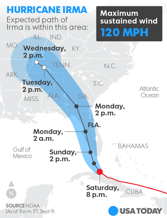
Because of its 350-to 400-mile-wide span, Miami could still feel some of the storm's brunt as it shifts to the west, with the metro area expected to be pounded by life-threatening hurricane winds, Feltgen said. Irma could maintain hurricane strengths into Georgia on Monday, forecasts show.
Emergency management officials said they were concerned about a trend of people who evacuated their homes opting to go back home now that Irma's track has veered toward the Gulf Coast.
Brevard County Communications Director Don Walker said, some people left one of the county's 21 designated hurricane shelters, and asked if they could return, if necessary. The answer is yes, but, ideally, they would continue to stay at the shelter until the storm passes.
"It's still going to be a dangerous situation," Walker said. "Don't make a dumb decision. Stay put until the all-clear is issued by emergency officials." That will likely would be Monday afternoon, at the earliest.
Noting the ever-changing predicted storm tracks, Walker said: "This thing has had people zigging and zagging all week long. It's got a lot of people second-guessing themselves. And it can still shift left or right."
In many places, though, the effects of the storm were already being felt Saturday. "The storm is here," Gov. Rick Scott said Saturday. By Sunday morning, a little over 380,000 people were already without power.
Florida Power and Light expects about 6 million people will be affected by the storm.
Broward County also issued a 4 p.m. curfew, asking people to stay off the roads. “This is a life-or-death situation at this point,” said Mayor Barbara Sharief. “You cannot walk the streets at 4 p.m.”
Irma’s wild weather even spawned a small tornado around 5 p.m., the National Weather Service confirmed. Videos and photos captured images of the twister on the ground in Oakland Park, about five miles north of Fort Lauderdale. The Fort Lauderdale-Broward County area has seen multiple tornado warnings Saturday, but the storm cell that spawned the tornado appeared to be moving west into the Everglades.
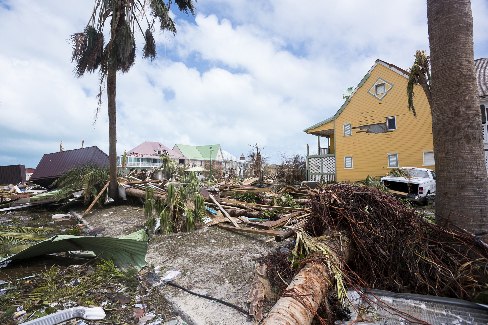
The storm has already killed at least 25 people since roaring out of the open Atlantic and chewing through a string of Caribbean islands.
Scott said 54,000 people had already taken refuge in the more than 320 shelters located in every county outside the highly vulnerable Keys.
"This is a deadly storm, and our state has never seen anything like it," Scott said from the Emergency Operations Center. "Millions of Floridians will see major hurricane impact with deadly storm surge and life-threatening winds."
Scott pleaded with people in evacuation zones to leave immediately. He added everyone in the state should stock at least three days of food and water because emergency response teams would be overwhelmed once the storm passed.
"We’ll get to you as quickly as we can, but you have to be part of this," he said. "You have to save your life.”
Scott also appealed for 1,000 volunteer nurses to help at special needs shelters
In Vero Beach, however, hurricane veteran Greg Von Zielinski hadn't loosened any of the 14 mooring ropes on his 54-foot sailboat at the municipal marina on the Atlantic coast. He planned to ride out Irma, the latest of more than a dozen he has experienced from New England to the Bahamas.
Even though Zielinski doesn't like Hurricane Irma's size, he's determined to stay, saying he feels safe aboard his ocean-going boat.
“This will be the worst single hurricane to hit Florida since Hurricane Andrew in 1992,” said meteorologist Joel N. Myers, head of AccuWeather.
Storm surge, the wall of sea water that roars ashore as a hurricane makes landfall, inundating coastal areas, will be "dangerous" and "life-threatening" for people who didn't evacuate.
If the storm remains at Category 4 strength, the ferocious 130 mph winds in Irma's eye wall will produce "catastrophic damage." Locations where a eye wall hits will see "power outages that will last weeks to possibly months. Most of the area will be uninhabitable for weeks or months," the hurricane center said.
"Few people alive have experienced a storm like this," Weather Channel meteorologist Bryan Norcross said. "It is reminiscent of the great hurricanes that unleashed their fury on Florida in the first seven decades of the 20th century ... and then for the most part disappeared."
Eric Blake, a meteorologist at the hurricane center, said “this hurricane is as serious as any I have seen.”
Rice and Stanglin reported from McLean, Va. Contributing: Jessica Guynn, Matthew Diebel