
A report issued by the National Park Service on Thursday gives a detailed timeline of the response by Great Smoky Mountains National Park officials to the Chimney Tops 2 fire after it started on Wednesday, Nov. 23, 2016.
The fire was first spotted in the evening of the day before Thanksgiving. Five days later, it spread outside of the park and into the nearby populated areas of Sevier County. Ultimately, more than 2,500 buildings were damaged or destroyed, about 200 people injured and 14 people killed in the fires.
The NPS report only covered the fire when it was inside the park boundaries.
The following is a summary of the timeline of the park's response to the fire laid out in the NPS report:
Wednesday, Nov. 23, 2016:
At approximately 5:19 p.m. EST, a fire was detected on Chimney Tops. The Fire Management Officer hiked into the fire as the incident commander and took along one other firefighter. The pair determined it was unsafe to take action at that time.
The Fire Management Officer had assumed command of the fire and was functioning as its Incident Commander. Due to the Thanksgiving holiday, most of the fire staff was on leave. Other than a Type 6 engine and two firefighters brought in with severity funding, the FMO had not staffed extra resources to cover leave requests and no leave requests had been canceled, even with the park in severity status.
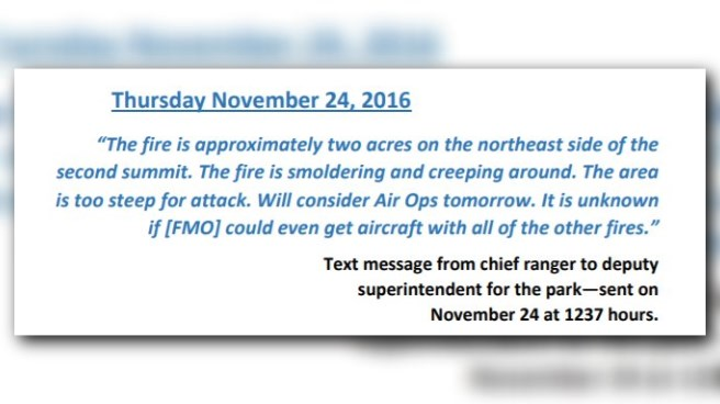
Thursday, Nov. 24, 2016:
Around 8 a.m., the FMO/IC met with four other NPS firefighters to continue work on the fire. According to the report, the group hiked in on the Chimney Tops Trail from the trailhead parking area to the NPS "not to proceed" warning sign along the east slope of Chimney Tops 1 and held a briefing. Three NPS firefighters said they were not comfortable climbing over Chimney Tops 1 and 2 to the fire.
The FMO/IC and one NPS firefighter continued on.
Conditions at the time were calm winds and it appeared the area received a small amount of rain overnight.
The Fire Management Officer, doubling as the Incident Commander, and one NPS firefighter started to look at ways to directly attack the fire. The two noticed the severely steep, rocky terrain and said it "was evident that building direct fire line in the boulders, cliffs and duff would be impossible."
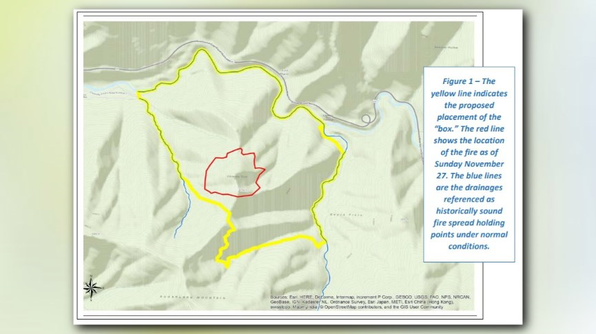
A "box" was identified for holding the fire to approximately 400 acres. It was not implemented immediately.
The fire continued to smolder while crews planned their next steps. The fire grew to about 2 acres in size.
Friday, Nov. 25, 2016:
Due to the cloud cover, attacking the fire from the air was out of the question. Crews looked for ways to implement the "box" but no action was taken.
Six people including the FMO/IC and NPS firefighters spent the day at the bottom looking for other options to contain the fire to the west, south and north.
During these scouting missions, the report says no fire was discovered burning along the drainages at either of these areas to the west, north or northeast of Chimney Tops 2.
Closures were issued for Chimney Tops and Road Prong trails.
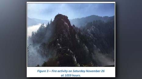
Saturday, Nov. 26, 2016:
A fire planning forecast was issued. Fire weather forecasts called for 40+ mile per hour winds on Monday with rain. The warning came in at 3 a.m. EST while the fire got more active. No crews were directly attacking the fire at this time.
The fire had grown to approximately 8 acres.
An abandoned user trail leading from near Chimney Tops 1 to the Sugarland Mountain Trail to the southwest for possible use of a fire containment line was located.
The fire had not yet burned onto the slopes directly west of Chimney Tops 2 and 1, but had continued burning slightly to the south along the east sides of Chimney Tops 2 and 1.
Sunday, Nov. 27, 2016:
The fire increased in activity and air resources were ordered. Helicopters made drops that afternoon. At 2:30 p.m., an infrared Multi-Mission Aircraft flight was conducted. Crews saw the fire had grown to 35 acres.
Some fire line construction was done on the proposed box while crews monitored the fire behavior and direct air operations.
Two Type 6 engines from the Bureau of Indian Affairs deployed with three crew members each. A Long-Term Fire Behavior Analyst was located near the fire and offered to assist the park.
Infrared camera images were taken of the wildfire for the first time.
The FMO/IC focused on the area to the southwest of the Chimney Tops. The area of the "box" shifted some as the fire backed away from Chimney Tops 1 and 2.
Around 8 p.m., the module and FMO/IC arrived at an overlook northwest of the Chimney Tops to observe the fire. That was below the fire, near the Newfound Gap Road tunnel just above the grade above the Chimneys Picnic Area.
In the report, the FMO/IC described how “you couldn’t even see the fire except for a couple glowing areas.” He said that visible fire behavior appeared minimal from this vantage point and this “glowing area” was located along the northwest side of CT2 and CT1 where there was some visible fire activity. The FMO/IC said that there “wasn’t a whole line—25 acres backing down.” In other words, there was no continuous line of fire visible, and no fire lines had been built in this visible area.
Since the FMO/IC thought the fire appeared quiet, he released all fire personnel at around 8:15 p.m. The decision was based on observations of minor torching and active flame on the ridges west and northwest of Chimney Tops 2.
Monday, Nov. 28, 2016:
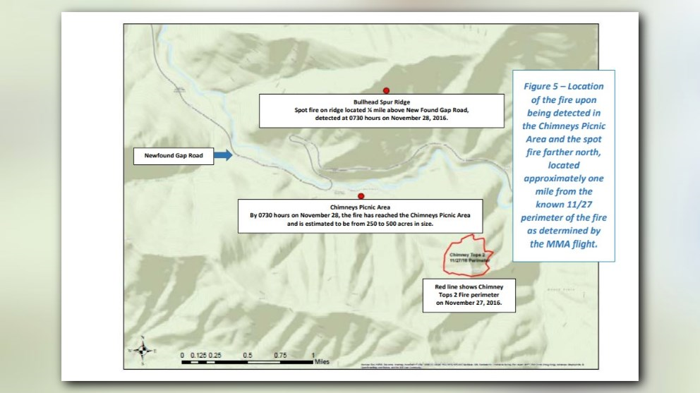
By 7:30 a.m., the fire was spotted across Newfound Gap Road and had grown to about 200 acres. At 11:35 a.m., the fire spots had spread to the Twin Creeks area.
A Type 2 incident management team was ordered by the park.
Monday's plan was to remove the leaf litter from the surface and move as far up the mountain as they could reasonably do so.
At 11:52 a.m., the Gatlinburg Fire Department activated a county-wide Wildland Task Force.
At noon, a voluntary evacuation of Mynatt Park was implemented.
At 2:30 p.m. the Gatlinburg fire chief activated a state-wide mutual aid call, and at 5:45 p.m., a brush fire was reported inside the city of Gatlinburg.
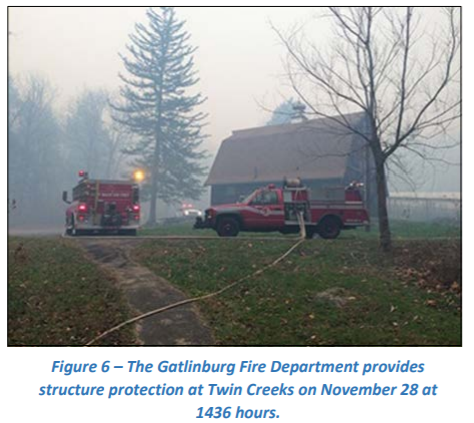
At the picnic area, the engines and their crews were using leaf blowers to create fire-holding lines around the picnic area buildings.
Fire was first spotted outside the park around 4:45 p.m. By 6, it had reached the Park Vista Hotel.